The Froxfield Entrenchments
We moved to Langrish in June 2007 but it wasn’t until the spring of 2008 that we discovered “The Avenue”, the footpath that goes up to Froxfield Green from Bordean Lane. We were bowled over by finding yet another lovely footpath so close to our new home, but were fascinated by the earth banks on either side of the path.
From Evelyn Hickox’s book “Some Aspects of Langrish Life” we learnt that there are several of these banks in the area and that they are called “Entrenchments”. She speculated that that they were probably defensive in nature and marked the boundary between the West and South Saxons in the 7th Century. Further Internet research and reading various reference books revealed very little additional information on the subject.
Then in July 2014, we went on a guided archaeological walk on Old Winchester Hill led by David Hopkins, Hampshire County Archaeologist. During the walk we asked him about the Froxfield Entrenchments; he said that they are a bit of a mystery as they have never been properly excavated. David told us that many archaeologists now believe that even such large features as the banks and ditches of the Iron Age fort at Old Winchester Hill were created to warn people migrating from west to east that the area of land they were approaching was occupied and owned. The banks would have been kept free from vegetation making their chalk white surfaces very visible from a considerable distance asserting proof of historical ownership of the surrounding area.
After meeting David, we redoubled our research activities and managed to come up with two important sources of archaeological research into the entrenchments which we list on the “references” page. The first, published exactly 100 years ago, is a charming book on Hampshire archaeology and contains detailed maps and elevations of the Froxfield Entrenchments. The second is a paper published in 1976 which includes maps of not just the Froxfield Entrenchments but also those in East/West Meon and East Tistead.
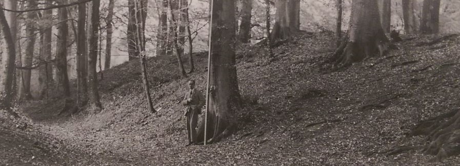
The entrenchments that start in Langrish north of Bordean Manor are called the “Froxfield Long Entrenchments” and run northwards for some 3 miles through Froxfield Green finishing up at the Froxfield Stud Farm straddling the Basing Dean Road. There are some interruptions where they have been built upon or ploughed out but it is fairly clear that when built they were one continuous feature. The second of our local entrenchments is called the “Froxfield Short Entrenchments” and is in the Slade Valley at High Cross. Both sets of entrenchments are extremely large, being 16 feet from the top of the bank to the bottom of the ditch next to them on the west side, and they are of very similar construction; so it is tempting to conclude that they were built at the same time.
A second set of entrenchments straddle the A32 from East Tistead to Colemore. A third set runs along the top of the hill between West Meon and West Meon Hut; going from west to east, they start at Marlands Farm, cross the A32 and continue eastwards all the way to Peak Farm.
There has been speculation that both sets of these entrenchments once linked up to the Froxfield Entrenchments. However after extensive walking in the area examining possible routes and studying of recent geophysical data, we think this in unlikely.
Our current view (and we have changed our minds several times already!) is that the Froxfield Entrenchments are not defensive but were built to control access from west to east. They are very substantial in size but it is difficult to imagine how the 3 mile long “Long Entrenchment” could be successfully manned. We further believe that the other 2 sets of entrenchments, which run east/west rather than north/south and are much smaller, were built for a different purpose, most likely as boundaries.
When were the Entrenchments created?
We know that the entrenchments existed in late Saxon times because they are mentioned in the Saxon Charters. There are 3 possibilities for when the Entrenchments were built: Iron Age, Romano British or Saxon times.
The least likely is the Romano British period as there are no other examples of such structures built at that time and this area was peaceful.
There is a reasonable case for them being of Iron Age origin. The building of hill forts suggests this was volatile period of history. The Old Winchester Hill hill fort is of definite Iron Age origin and controlled passage along the South Hampshire Ridgeway. The entrenchments could have built at this time to control the through routes in this area of Bordean Gorge, Basing Dean and Ridge Top Lane.
However, the most likely answer is the seventh century AD. This area, east of the Meon Valley and west of the modern Sussex border was the subject of frequent rivalries between the West Saxons and the South Saxons. In 616 AD the South Saxons were granted the Hundred of Meon and Meonstoke (Langrish was part of the Hundred of Meon.) In 674 AD the West Saxons regained their settlements. Perhaps at this point the South Saxons retreated and created the Entrenchments to keep an eye on their West Saxon rivals and deter them from encroaching further east.
What Next?
We plan to carry on with our research to try and tie down when the entrenchments were built. We have been using LIDAR (Light Detecting and Ranging) data to try to trace the true extent of the entrenchments. However, there is only one way to really establish their origin and that is an archaeological dig. Interestingly David Hopkins suggests that you wouldn’t dig into a bank but rather the ditch where there would be far more interesting material. He is also keen that that it should be done at the edge of the existing entrenchments to protect what’s left; they are after all listed National Monuments.
Ian and Betty Wesley
